Successful conclusion of the second Research Mission in Romania
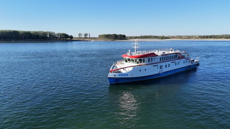
The SUNDANSE project is thrilled to announce the successful completion of its second intensive research field campaign for the Romanian Use Case aboard the advanced research vessel REXDAN. From August 23 to September 10, 2025, the REXDAN navigated a critical stretch of the Danube, between River Kilometers 597 (Turnu Măgurele) and 630 (Corabia). This mission presents an extension of the first surveillance campaign and marks a step forward in refining our understanding of the Danube’s complex hydrological and morphological characteristics, laying crucial groundwork for sustainable sediment management solutions.
SUNDANSE expert-team onboard REXDAN included: “Dunarea de Jos” University of Galati, Marine Research, University of Vienna and Galati Lower Danube River Administration.
The SUNDANSE team performed several key activities, including:
- Sediment sampling and transport,
- Bathymetric measurements,
- Velocity measurements,
- Topographic measurements and
- Water and microplastic sampling.
Sediment sampling and transport
During the recent mission, the REXDAN vessel served as a floating laboratory for a crucial sediment sampling campaign. Sediments are more than just riverbed particles, they act as natural archives, holding a history of human activity and pollution. The purpose of this activity was to collect and preserve sediment samples from various sections of the Danube, from natural zones to human-influenced areas, for detailed analysis of grain size and pollutant concentrations.
Marine Research team provided expertise in grain size and concentration determination, while the University of Vienna focused on collecting samples for analysing tire additives. Together, the team collected 21 sediment samples and profiled 43 points using specialized acoustic and laser equipment. This comprehensive approach ensures that the data is credible and suitable for long-term monitoring. The preserved samples will now be transferred to laboratories for detailed chemical and physical analysis, creating a comprehensive dataset to characterize pollutant concentrations and support a healthier Danube.
Bathymetric measurements
One of the core activities of the mission was bathymetric measurements, a precise method for mapping the river’s underwater terrain. Led by a unified team from “Dunarea de Jos” University of Galati, Marine Research, and Galati Lower Danube River Administration, this campaign was carefully planned with evenly distributed survey routes to ensure maximum coverage. The team used high-resolution multibeam sonar systems and GNSS positioning to collect accurate depth data, revealing a detailed picture of the riverbed. This work is crucial for understanding the Danube’s bottom features, which in turn supports safe navigation and environmental monitoring. The data collected will be used to create a second bathymetric model to validate the results from the first survey campaign.
This activity went beyond simple depth measurement, because it provides us with a detailed understanding of the underwater environment – revealing hidden slopes, channels, and sediment patterns. The collected hydrographic data was calibrated for tidal variations and water level fluctuations, ensuring its accuracy. This crucial step guarantees that the bathymetric data can be integrated with terrestrial and aerial surveys, creating a unified digital model of the entire landscape, both above and below the waterline.
Velocity and discharge profiles
The mission’s third key activity was measuring velocity measurements and discharge profiles to understand how water moves through the river. By using specialised ADCP (Acoustic Doppler Current Profiler) technology from moving boats, the team recorded real-time flow data across 11 specific transects on the Romanian use case, from bank to bank. These measurements are crucial for understanding flow behavior on the main and secondary channels, which helps to identify areas of potential erosion or sediment buildup.
The “Dunarea de Jos”University of Galati and Marine Research worked in synergy to ensure the accuracy and reliability of the data, managing the technical deployment and navigation of the boats. Their efforts successfully captured accurate flow data, highlighting significant velocity variations across different river sections and upstream of Calnovat Island. This information is vital for understanding how water movement influences sediment transport and aquatic habitats. The next step will involve a detailed analysis to generate comprehensive flow assessments and physical models, which are fundamental to providing a complete picture of the river’s hydrodynamics.
Topographic measurements
The mission’s fourth activity focused on topographic measurements, an essential part of the project’s holistic approach to river mapping. The primary goal was to capture precise, high-resolution data of the terrain and build a 3D model of the islands and banks along the Danube river, specifically in the Turnu Măgurele to Corabia area. This activity provides crucial data on areas that cannot be measured using bathymetric methods.
To achieve this, the team deployed Unmanned Aerial Vehicles (UAVs) equipped with LiDAR sensors and advanced photogrammetric cameras. The LiDAR sensors captured centimeter-level elevation data, while the photogrammetry provided high-resolution imagery for realistic textures and shapes. This dual-technology approach captured both visible and invisible features, revealing subtle terrain shifts and hidden structures beneath vegetation.
This work was a true collaborative effort. Marine Research designed and optimised the flight plans, while “Dunarea de Jos”University of Galati and managed the UAV deployment, flight operations, and collected complementary ground data to ensure the accuracy of the aerial surveys. This systematic process guaranteed an efficient dataset for 3D modeling of the Danube river, which will guide the engineering and planning team in creating the physical scale model.
Water and microplastics sampling
The fifth activity of the mission focused on water and microplastics sampling to investigate the spatial variability of pollutants in the Danube’s water. Researchers collected samples along the Turnu Măgurele to Corabia sector to get a representative snapshot of the river’s overall water quality. This work is essential for evaluating local exposure levels and the potential impact of chemicals on freshwater ecosystems.
The team collected samples from natural depositional zones as well as areas with human influence, such as active navigation channels, port zones, and wastewater discharge points. The analysis of these samples will determine the concentration of various pollutants, including heavy metals, pesticides, polycyclic aromatic hydrocarbons (PAHs), and microplastics. The samples were preserved with quality assurance measures to ensure the credibility of the data for long-term monitoring.
We are beyond proud!
Researchers on board the REXDAN vessel returned to their homes after two weeks spent on the river, and we couldn’t be prouder of the whole team and incredible results! The successful completion of the SUNDANSE project’s second Research Mission for the Romanian Use Case is a major milestone in our commitment to a healthier Danube river. This intensive expedition was an example to the power of an integrated approach, where every activity played a crucial role.
Now, as the data moves from the vessel to the laboratory, we look forward to translating this research into actionable strategies that will help ensure a clean, safe, and resilient Danube for generations to come.
Romania’s television, covered the REXDAN mission in its news broadcast.
Take a look at the videos below!